Columbus State University News
‘Cartographic America’ rare maps book visualizes colonial to antebellum history in U.S.
December 16, 2024

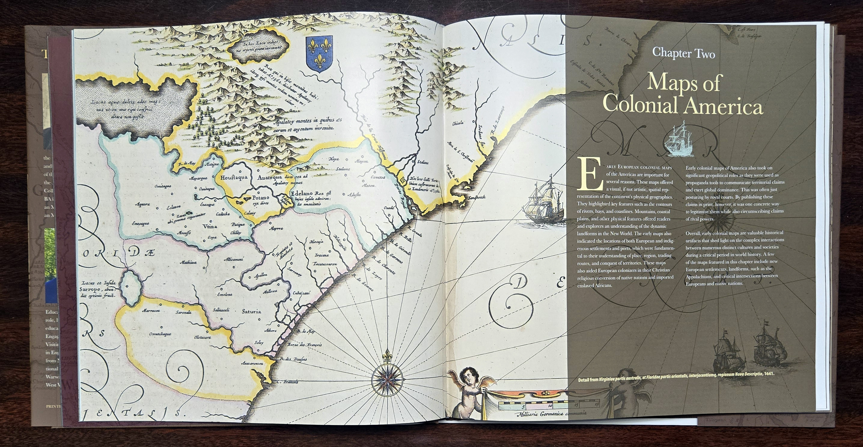
The Columbus State University Press has released its first major hardback book: “Cartographic America: Selections from the J. Kyle Spencer Map Collection.” This visually stunning and intellectually rich work by two university faculty members was curated from the university’s one-of-a-kind map collection.
The 123-page, coffee table-style book charts nearly 300 years of American historical geography from the late 1500s to the late 1800s. It uses the unique J. Kyle Spencer Map Collection—housed in the Columbus State University Archives & Special Collections since 2013—as a lens to illuminate some of the most pivotal years of American history. Its authors are David Owings, associate dean of CSU Libraries and head of its Archives & Special Collections, and Dr.Eric Spears, the Mildred Miller Fort Foundation eminent scholar and chair of international education.
 “Collectively, these maps document the evolution of the Americas—including Europeans’
first contact with local indigenous tribes, expansive colonization by the British,
colonial revolution and the United States’ ultimate independence,” Owings (pictured)
explained. “Each of these maps has its own incredible story, and as such, we have
strived to contextualize each in its original historical period to provide readers
a unique way to discover the past.”
“Collectively, these maps document the evolution of the Americas—including Europeans’
first contact with local indigenous tribes, expansive colonization by the British,
colonial revolution and the United States’ ultimate independence,” Owings (pictured)
explained. “Each of these maps has its own incredible story, and as such, we have
strived to contextualize each in its original historical period to provide readers
a unique way to discover the past.”
As Columbus State faculty members and scholars in their respective fields, both Owings and Spears spent at least a year researching and drafting commentaries for each map in the book. Those commentaries accurately depict and frame the maps in their historical time periods. As a result, the book has broad academic and teaching applications— not just in the United States, but internationally, considering that many of the book’s maps are of British and French origin.
 “‘Cartographic America’ offers a compelling journey through the early European formation
of North America. By examining historical geography, this book provides a uniquely
spatial perspective on the colonial competition among the British, French and Spanish,
and their collective impact on the First Nations in the American Southeast,” said
Spears (pictured), whose academic specialty is geography.
“‘Cartographic America’ offers a compelling journey through the early European formation
of North America. By examining historical geography, this book provides a uniquely
spatial perspective on the colonial competition among the British, French and Spanish,
and their collective impact on the First Nations in the American Southeast,” said
Spears (pictured), whose academic specialty is geography.
The book is the inaugural publication in CSU Press’ “The Tapestry Series.” Like the series’ first volume, future publications will explore rich, diverse narratives in history, culture and the arts.
Visit the Columbus State University Press website as it is updated with information about purchasing “Cartographic America: Selections from the J. Kyle Spencer Map Collection” online and at Columbus-area retailers.
WHAT OTHERS ARE SAYING ABOUT 'CARTOGRAPHIC AMERICA'
 “Maps occupy a curious place: part utility and part art. This is evident in the book
‘Cartographic America: Selections from the J. Kyle Spencer Map Collection.’ Here we
have a lovely book that explores this division with maps of North America from the
earliest European exploration to the late nineteenth century, with emphasis on the
Southeast, and with a chapter devoted to maps of Georgia before and after statehood.”
—Stephen Goldfarb, Ph.D., historian and retired Alabama-Fulton Public Library reference librarian
“Maps occupy a curious place: part utility and part art. This is evident in the book
‘Cartographic America: Selections from the J. Kyle Spencer Map Collection.’ Here we
have a lovely book that explores this division with maps of North America from the
earliest European exploration to the late nineteenth century, with emphasis on the
Southeast, and with a chapter devoted to maps of Georgia before and after statehood.”
—Stephen Goldfarb, Ph.D., historian and retired Alabama-Fulton Public Library reference librarian
“A visual feast for anyone interested in early maps of the Americas—especially the Southeast and the Caribbean. Whether you are simply a history buff or an academician, there's something for everyone here...” —Robert Gamble, senior architectural historian emeritus, Alabama Historical Commission
 “This book is a joy, being well written and edited with a good layout and sharply
defined maps. It will be useful not only for historical and geographic research but
also just for reading pleasure.” —Stanley W. Trimble, Ph.D., author and professor emeritus of geography, UCLA
“This book is a joy, being well written and edited with a good layout and sharply
defined maps. It will be useful not only for historical and geographic research but
also just for reading pleasure.” —Stanley W. Trimble, Ph.D., author and professor emeritus of geography, UCLA
“The result [of ‘Cartographic America’] is a tour de force through Georgia and American history that is both revealing and provocative. The book is a riot of color and a celebration of design, but also a tangible resource for understanding several important eras of our nation's past.” —Mike Bunn, author and historian
ABOUT THE SPENCER MAP COLLECTION
The J. Kyle Spencer Map Collection maps the formation of the United States and four centuries of American cartography from the late 1500s to the 1800s. It documents the movements of early explorers and American colonists, narrowing its scope to the Southeast and Georgia beginning in the early 1700s and continuing through 1864.
 The late J. Kyle Spencer meticulously acquired and curated this collection during
his lifetime. He donated the collection to the CSU Archives & Special Collections
in 2013 before his passing in 2015. He and his wife, Sara Davis Spencer (pictured together), were also the benefactors
establishing the university’s Spencer House in Oxford, England, and scholarships funding
study abroad experiences where possible.
The late J. Kyle Spencer meticulously acquired and curated this collection during
his lifetime. He donated the collection to the CSU Archives & Special Collections
in 2013 before his passing in 2015. He and his wife, Sara Davis Spencer (pictured together), were also the benefactors
establishing the university’s Spencer House in Oxford, England, and scholarships funding
study abroad experiences where possible.
Rex Whiddon, senior associate vice president for leadership philanthropy & strategic initiatives, credited Spencer and others with contributing to the eventual publication of “Cartographic America.” Those included the late Donald L. “DL” Jordan, a businessman and author whose generosity and foresight in 2016 endowed and created the Columbus State University Press, and Advocates for the Archives board member Katherine Jordan Waddell, whose generous philanthropic support made the publication possible.
Whiddon also acknowledged the pivotal role of Dr. John Lupold, a professor emeritus of history who guided the Spencer Map Collection to Columbus State and laid the groundwork for the book by drafting an annotated catalog of selected maps. Additionally, he recognized the efforts of then-dean of Libraries Mark Flynn and Dr. Timothy Mescon, Columbus State’s fourth president—both of whom helped arrange for the maps’ placement in the university’s archives.
ABOUT THE ARCHIVES & SPECIAL COLLECTIONS
Established in 1975, the Archives & Special Collections—a unit of the Columbus State University Libraries and located on the ground floor of the Simon Schwob Memorial Library—has served as a repository for materials documenting the history of the university, the city of Columbus and the broader Chattahoochee Valley region. Its collections span 5,000-plus cubic feet of material in more than 500 distinct collections, which include personal and family papers, business records, photographs, art, maps, blueprints and much more.
Among its most significant and noteworthy collections and artifacts are the papers of Col. Richard R. Hallock, the J. Kyle Spencer Map Collection, the Ledger-Enquirer's historical photograph archive, and records from the area’s textile industry, including the Bibb Manufacturing Company and Eagle & Phenix Mills.
Media contact: Michael Tullier, APR, Executive Director of Strategic Communication + Marketing, 706.507.8729, mtullier@columbusstate.edu